Showing posts with label traffic management. Show all posts

Thursday, September 25, 2014

Curb enthusiasm

At the park's western corner, the boundaries between
pedestrian, car, and rail zones are poorly defined.
For a variety of reasons, most of them familiar to Hudsonians, it is difficult to agree on the boundaries of discussion regarding the Seventh Street Park. Hopefully, a discussion of the park's literal boundaries—its curbs—will prove less controversial.

The park's western corner is a good place to start. My informal but repeated observations indicate that this is the busiest corner of the park and the entry point for the majority of park users. Unfortunately, the rail line that infamously crosses the park slices through this corner, smearing the distinctions between the pedestrian, motor vehicle, and rail realms. The sidewalk and curb dissolve into asphalt which dissolves into the rail right-of-way which dissolves into active lanes of traffic; where is one to safely stand while waiting to cross the street? There are no barriers to guarantee refuge, and the physical and psychological assault comes from more directions than can be confidently monitored. The situation is only slightly better for those approaching the corner from the other side of the street, where the awkward boundaries combine with other poor physical cues to present a picture that on good days is ambiguous, and more often is repellent.

A simple curb bumpout at this corner would solve much of the problem by providing a larger, clearer pedestrian zone. Here are two existing bumpouts:
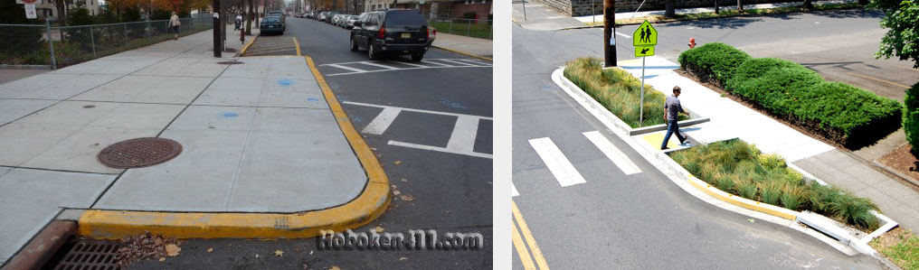
Left: a basic curb bumpout in Hoboken, New Jersey (photo from hoboken411.com). Right: a landscaped example in Seattle,
Washington (photo from myballard.com).

And here are views of 7th and Warren with and without a bumpout at the corner of the park:
From there, it is worth seeing if the rest of the park's perimeter would benefit from similar attention. The easier we can make it for people to cross the street to the park, the more users the park will have. And indeed, when deployed on both sides of an intersection, curb bumpouts can reduce pedestrian crossing distance by as much as fifty percent. They have many other advantages compared to straight-curbed intersections: they allow roadway signs to be placed closer to drivers' center of vision. When used as planting beds, they reduce surface water runoff into the roadway. And they have a generally positive effect on parking: they don't steal spaces because their locations already are no-parking zones, and they make it more difficult for scofflaws to park too close to an intersection. Perhaps most importantly, curb bumpouts alter the image of vehicle-heavy streets by advertising the right of pedestrians to inhabit intersections. Their one significant shortcoming is that they can complicate snow removal. This is less of a problem today than it was twenty years ago, however, as many municipalities now invest in smaller, more agile snow removal equipment.

As I looked into all of this, the question arose as to whether any of the streets bordering the park can be narrowed in their entirety. All the streets are now two-way; and I've never been convinced this is needed on Seventh Street and Park Place, which run along the long sides of the park. Whenever I drive on one of these streets, I find myself wondering if I should be driving on the other one.

GIF animation may not work in some mobile browsers.
The diagram at right shows a suggested pattern with one way traffic on the two long sides of the park. I don't make this suggestion lightly, as I usually am averse to converting two-way urban streets into one-way streets. Twentieth century planners frequently did this to expedite vehicle flow without regard for pedestrian experience. But on the two streets in question here, there is little chance of vehicles gaining prominence. We'd be creating narrower, one-lane, one-way streets that are quite short, and we'd grant any leftover real estate to pedestrians.

You might notice that I've continued the one-way traffic on Seventh Street into the next block heading southwest (lower left in diagram). At present, this block is ridiculously, if pleasantly, complex: the street is narrow, there's a train running down one side of it, there's pull-in parking on the other side, and there's two-way traffic. There might be a reason for this last aspect that I cannot surmise, but my working assumption is that a one-way accommodation will be adequate because Sixth Street already flows in the opposite direction. Ultimately, this is a question on which to consult the traffic engineers.

Putting all this together, I've suggested below some possible changes to the curb boundaries of the park. The sidewalks are wider and the crosswalks to the park are shorter than at present. Parking has been maintained around the entire perimeter. The biggest license I took was in showing pull-in angle parking on Park Place; I'm not sure there is enough space.

If the irregular curb geometries look odd to your eye, it likely is due to the abstract nature of the drawing. In the real world, you've almost certainly encountered similar curb shapes many times without such concerns arising.

For now, I've represented the park with an expanse of green. This does not indicate a design intent but the absence of one. I'll continue my sporadic investigations into what might happen inside the park's boundaries another time.

Thursday, September 18, 2014

A crown for Warren Street

Above: Route 9 (solid line) currently jughandles through Hudson because a narrow,
two-block section of roadway prevents a simpler, straighter route (dashed line).
Below, the existing intersection of Warren Street with Worth and Prospect.

In a recent post, I looked into rerouting U.S. Route 9 as a way of reducing truck traffic within the Hudson street grid. I raised the possibility of simplifying the route by widening a narrow, two-block stretch of Prospect and Fairview Avenues, and as an additional option, merging Prospect and Fairview into a continuous street.

In this post I'll look at the intersection where my rerouting began, the meeting of Warren Street with Prospect Avenue and Worth Avenue. Some Hudsonians complain about this intersection because of the three-way stop signs. Personally, I find communal value in the eye contact and informal coordination they call for, but at rush hour, when I almost never drive, such charms are perhaps lost.

Whether or not the intersection is a failure from a traffic standpoint, it is most definitely a failure from a civic standpoint. This is an important intersection in Hudson. It marks the head of Warren Street, the cultural and commercial spine of the city, a street celebrated for its architecture, restaurants, and galleries. But while the bottom end of Warren Street is anchored by a promontory overlooking the Hudson River, here there is no indication of the street's significance. There is no major building or space to complete the street axis and pull walkers to its top end; the strongest architectural gestures are an auto repair garage and a marginally maintained, 1870-ish flop house. Besides presenting a significant aesthetic problem, this represents an economic and cultural problem, as properties at this end of Warren Street have tended to languish.
Warren Street is the commercial and cultural spine of Hudson. It is is received by a park at the Hudson River, but it lacks a
significant marker at its upper end.

Below I offer a suggestion for anchoring the top of Warren Street. I've realigned Prospect and Worth Avenues into a continuous street, and extended Warren to meet them in a T. I also rerouted the alley behind Worth Avenue to connect with Prison Alley. These changes would result in the loss of two houses (one architecturally undistinguished) and the auto repair garage. The gain is a clear beginning/end to Hudson's main street and a large, developable parcel to the southeast.
A street realignment and new building and plaza offer a civic gesture at the head of Warren Street.


Portland, Maine
On the new site I've suggested a large building and plaza to preside over Warren Street. The location lends itself to a public building such as county offices, a police station, or a library. Unfortunately, these functions are all in the process of being relocated to other sites in Hudson. A church, grand hotel, or apartment building might work, and the proximity of the hospital suggests an administration building. However, some of these uses might not lend the right civic note. But it's fun to imagine something new and impactful at this location. A good street should have a good beginning. And a good end.

Wednesday, September 3, 2014

On gas stations, street walls, and beer gardens

The view from the park to the northeast/east is unwelcoming.
Urban spaces succeed through their relationship with their context. If a public space is of a type that is to be activated by workaday activities, it usually needs to be fronted by a well-defined street wall. Strong built edges generate life in a park, define it as a meaningful place, and provide a sense of "hereness."

Hudson's Seventh Street Park is defined reasonably well on most of its perimeter, where two and three story buildings directly front the sidewalk. But the northeastern/eastern side/corner is "spatially leaky." A homely, one-story Citgo station sits sixty or more feet from the public way. A train right-of-way immediately west of the Citgo station and some odd building and street geometries to the east contribute to additional spatial weakness. A park user walking toward this corner is presented with a destination that ranges from unclear to unpleasant.

Most of the park's perimeter has fairly well-defined street
walls, but on the northeast and east it is spatially leaky.
Of the several offenders, the Citgo station receives the most frequent criticism. I hear occasional, hopeful musings that economic pressures from increasing real estate values will cause it to eventually go away. I think this is unlikely. It is difficult to get rid of gas stations under almost any economic circumstance, because they earn more than almost any other use. If we are going to address the problems at this end of the park, I think it would be wiser to seek an urbanistically friendlier design for the gas station site that maintains Citgo as a tenant. If nothing else, the exercise is good practice, design-wise and emotion-wise, for learning to work with undesirable constraints.

At present, vehicles enter and exit the Citgo site on the same side, i.e., Columbia Street (below left). This design decision, made long ago, required that the building be sited on the back of the site. A more sympathetic building placement can be achieved by employing a drive-through circulation pattern, from Columbia Street to the alley (below right). 
Vehicles currently enter and exit the site
via Columbia Street.
A through circulation pattern would permit a
friendlier building placement.
This would allow the placement of a building on the Columbia Street edge, where a building stood years ago. Ideally, a new building here would be three stories high (the former building was two stories) and would house ground floor retail (including the gas station mini-mart) and other uses that would activate the sidewalk and park edge.
The Citgo site with a 3-story building fronting on Columbia Street

This would solve part of the problem, but the railroad right-of-way to the west (i.e., left) of the gas station would remain spatially leaky. At bottom, I've illustrated one way of strengthening the street wall here. I offer no warranties on the quality of any of the architecture represented, although I suspect some will find the beer garden compelling.

In a perfect world, we wouldn't need to concern ourselves with oddities such as a gas station and a railroad on our town square. If we were facing the decision today for the first time, would any of us, other than Citgo and ADM, choose to have them here? And yet many Hudsonians, even some staunch formalists, admit to liking the intrusion of the railroad. It is part of who we are, part of what the park is, part of what makes Hudson different from other places. Indeed, the things that by some measures don't belong in a city are the very things that make it authentic and interesting. Granted, it may be easier to romanticize a railroad line than a Citgo sign. But before declaring that a conclusion, we probably should check in on the question with the Red Sox fans among us...perhaps even some Yankees fans.
Some possibilities for strengthening the street wall at the northeastern side of Hudson's Seventh Street Park.

Monday, August 4, 2014

900 Columbia Street: not necessarily a loss (redux)

The other day, I proposed a traffic circle at the Prospect Ave./Columbia Street/Columbia Turnpike intersection. Afterward, I recalled another scheme I created last year for the same intersection. I'm surprised I forgot about it, as it was more directly stimulated by the proposed demolition of 900 Columbia Street. The scheme would eliminate thru-travel on a portion of Columbia Street and route all traffic through a conventional four-way intersection. It would look like this: 
The genesis of the scheme was an statement by the owners of 900 Columbia Street that they would create a garden in lieu of the building they were tearing down. The implication was of a public amenity, presumably of greater value than a generically shrubbed parking lot buffer. At the time, I thought, why not ask the owners to put their money where their bulldozers were by asking them to endow a larger public garden in an extended front yard? Politically speaking, this might have been an attractive trade-off for the tortured debate on the building's demolition. Here is the scheme with the garden:
None of this is to say the scheme wouldn't be viable today. I think I forgot about it because I usually don't like to interrupt through streets, particularly in urban districts where street identities are already compromised. But I think I find this scheme superior to the traffic circle scheme, in regard to traffic management as well as pedestrian environment. It's also likely it would require less extensive alterations to the surrounding infrastructure.

A quarter-mile to the west, Columbia Street was recently rerouted in a similar fashion where it meets Green Street:
Westbound thru-traffic, which used to follow a straight path from right to left in the photo, is now diverted around a small triangular island. Eastbound traffic, however, maintains its previous thru-route. What would happen if we also rerouted the eastbound traffic? 
We'd again end up with a simplified, seemingly more manageable four-way intersection. Additionally, the triangular island, which is currently too small to attract users or dignify the memorial now sited on it, could be extended southward to create a plaza that engages the existing buildings on that edge.
Some planters, benches, and other improvements suggest a quite palatable urban space. With the (admittedly glib) replacement of the gas station on the west corner, the intersection might become a place to enjoy, rather than simply get through. Notice that the Hudson City Center (the large brick building at the top of the photo), which now seems alien to its site and to Hudson, looks much more anchored in space. And considered in context with the above suggested improvements at Columbia Turnpike and the proposed revamping of the Seventh Street Park a block to the west, one can imagine a rather pleasant progression down Columbia Street into the city grid, wending through a series of thoughtfully considered public spaces.

Thursday, July 31, 2014

900 Columbia Street: not necessarily a loss

 The worst intersection in Hudson is at the meeting of Columbia Street, Columbia Turnpike, and Prospect Street at the eastern end of the city, between Columbia Memorial Hospital and the cemetery. An agglomeration of acute and obtuse angles, grade changes, curves, and not-fully-expected stop signs contribute to a situation that one cannot negotiate logically or intuitively. I typically traverse the intersection in mild terror and complete it in amazement of not needing to detour into the hospital.
The intersection as it exists is shown below. I fudged the building at 900 Columbia Street, which used to abut the sidewalk but was torn down last year. I've simply slid it back on the site to approximate the new building that now sits there.

Existing intersection
While many were lamenting the demolition of 900 Columbia Street last year, I wondered if it presented an opportunity to more favorably configure the intersection. While the basic street geometries can't be changed, perhaps, I thought, the removal of 900 Columbia would allow a traffic circle to organize the mess. I'm not generally a fan of traffic circles, but they are effective at taming complicated street geometries. And statistically they are the safest type of intersection by a wide margin: accidents are almost never bad, because everyone is moving in the same direction and contact tends to be low-speed and glancing. Compare that to the current intersection, where an easily missed stop sign can result in a driver getting T-boned by a car traveling at full speed.
Another problem is that the intersection makes for a terrible entry into the city when approaching from the east. The hilly topography combines with the weird street angles to give one a sense of sliding away or being deflected from his desired path. And the hospital, a very large building compared to those that precede it, lacks a dignified presence. (The hospital does not have a proper presence on any of the streets on which it fronts, a topic for another time.)
Below is the intersection with a traffic circle overlaid. My dimensions are crude, but it turns out that I didn't need to use the front yard of 900 Columbia. In fact, I kept the whole northern edge of Columbia Street intact. If a larger circle (ellipse?) is needed, space perhaps can be taken to the east, where the existing house has gained a much larger front yard, and to the southwest, where the existing hospital parking lot is inefficiently configured.
Intersection with suggested traffic circle

The hilly topography is a concern, as a traffic circle needs to be level. Some significant regrading would be required, particularly at the south and east, where Prospect Avenue and Columbia Turnpike terminate. These roadways would have to be lowered, which would result in a steeper hillside at the edge of the cemetery.

Another concern is that traffic circles often are ugly. But when thoughtfully landscaped, they can be a community amenity that imparts not only safety, but a pleasing welcome for drivers and pedestrians. The one shown here isn't the most stunning example, but you get the idea.
Planting by Shippan Point Garden Club, Stamford CT
If I were to sermonize briefly here, I would question the zero-sum view that historic preservationists too often take toward buildings and cities. In fighting the loss of old buildings, they often fail to engage the city as the creative enterprise it actually is. Their focus is on what might be lost, not on what might be gained. Of course, we didn't need to tear down the old building at 900 Columbia Street to consider improving the intersection on which it fronts. But the possibility (and ultimately the reality) of its loss is in fact what sparked the "what if...?" exploration here. To the rearward-facing historic preservationist, such exploration is not undertaken because a loss is unavoidably a loss. But to the creative person, losses are opportunities.