Showing posts with label Hudson NY. Show all posts

Thursday, June 13, 2019

How to solve the wrong problem

At Tuesday night's meeting of the Hudson Planning Board, Colarusso & Sons put forth a proposal to mitigate the visual intrusion of its gravel operations on the Hudson waterfront. Colarusso provided this existing view of the area; you are looking toward the river with the Basilica behind you:
Below is the same view, with Colarusso's proposed vegetative screening added:


At first, this looked to me like one of those "spot the differences" puzzles I hated as a kid. I would grow annoyed before finding the first one. But I have to admit that the truck at the right edge of the upper image is rather effectively screened from view by the proposed plantings.


So what's the problem? Well, when you take into account the path the trucks take between 40 and 280 times per day (according to a good source), the screening has little to no effect. Here is what one of these trips looks like from the same location, albeit with a shinier truck:
Here is the same view with the vegetative screening added:

Can you spot the difference? I didn't think so. As long as the truck path remains where it is, the real intrusion into the district will not be mitigated.

Move the crossing. Solve the real problem.


Monday, April 8, 2019

Stewart's proposal update


Here is an update to my post of last month. Hopefully, it is self-explanatory enough for now. I will post additional drawings and descriptions of the public outdoor space (#11, ice cream window, picnic area, etc.) as I am able.

EDIT: Here is a closer view of the building as seen from Fairview Avenue, showing the corner entry, ice cream window, and outdoor space. There may have been some confusion last month as to what I mean by "corner entry": there are two doors located a few feet from the front left front building corner. One faces the street, the other faces the gas pumps. (The two men pictured have just exited from the respective doors.) Because everyone comes and goes from one location, sociability is increased, while security concerns for employees are eased, as they effectively have to watch only one entry/exit.

Wednesday, March 13, 2019

One way to stop the Stewart's expansion and six ways to make it better

The new Stewart's store will be sited almost exactly in the footprint of the yellow house on the far right.


Stewart's plan to expand at Green Street and Fairview Avenue has been moving forward. We will see the latest version at the next meeting of the Hudson Planning Board tomorrow at 6:00PM. Stewart's ambitions were greased last year by the enactment of Local Law No. 5. Prior to it, Stewart's, as a nonconforming use in a residential neighborhood, was forbidden to expand. But with the law at its back and now two adjacent residential properties in hand, it is poised to build a vastly enlarged gas station and convenience store on the site.

I've been looking for a hole in LL#5, as I believe that good urban planning should facilitate the development of locally-owned businesses, not externally-owned businesses that remove local money. Not to mention that this will be an unattractive, suburban project inserted into a semi-urban site. Several times I thought I had found a loophole, only to be disabused on my next reading. The only obstacle to Stewart's ambitions I see is for someone to sue the city for "spot zoning," the largely illegal practice of preferentially zoning a specific property. This case seems to tiptoe very close to, if not over, that line.

Until that happens, I am heeding the frequent exhortations of Walter Chatham, the Planning Board's head, to "not let perfect be the enemy of the good." This exhortation has been embraced by Stewart's own representative, who echoed Chatham's axiom to him in initially engaging the board.

Stewart's proposed site plan
In this spirit, I took on a brief study of the site. First, let's look at Stewart's current proposal (right). It is a little hard to read, given that the proposed scheme is overlaid on the existing conditions. But if you know the site you can discern the major pieces. The existing gas pumps and canopy are at the lower left corner, at a 45 degree angle. The existing building, to be demolished, is tucked partly under the proposed canopy. Once you spot the two existing structures, you will realize how much larger the new site will be—double the size of the existing one.

My proposal looks superficially similar, as I could not move the basic pieces very much. But some key tweaks will go a long way toward creating a project that will look like it belongs where it was built. Here is my proposed site plan:
My proposed site plan


The following explanations are keyed to the plan.

1. New landscaped traffic island. The existing intersection is big, open, and ugly, with lots of asphalt, and the new Stewart's will bring even more paved openness. I propose a traffic island between the existing thru-travel and dedicated right-turn lanes on Fairview to provide softening and better spatial definition. Ideally, the island would be larger than what I drew, with the lower left corner (as viewed on the drawing) squared off to create a more triangular shape. However, trucks turning left from Green onto Fairview need the radius shown.

2.  Revised curb radius at transition of Fairview to Green. This adjustment will narrow this portion of Green Street NW-bound from two lanes to one. The space gained will become a planting buffer that reduces the scale of the intersection and screens views of the gas pumps. Incidentally, there is an existing bus stop on Green Street at the proposed curb cut location. If this is or will be an active stop, it will need to be moved a little farther up the street (for either Stewart's or my scheme).

3. New pedestrian crosswalks, signals, and signage. I've gone back and forth on the best crosswalk locations. Pedestrians usually should cross at corners, but this would force two of the crossings to traverse the traffic island and right-turn lane, which seems awkward and would reduce planting space on the island. So I have shifted them away from the corner to allow pedestrians to cross the streets perpendicularly.

4. Geometry tweaks. It's hard to tell on the Stewart's plan above, but the proposed gas pump canopy is skewed a few degrees off the geometry of the houses on Green Street. I suspect the proposed building is similarly skewed. That this is hard to discern might make it seem it can be ignored, but this is precisely the kind of thing that causes a building to subliminally convey, in real life, that it is alien to its surroundings. So let me put a finer point on things:
a. Set the gas pump canopy and the Green Street facade of the new Stewart's building exactly parallel to the facades of the existing houses on Green Street. Ditto for all parking spaces, interior curb lines, etc.
b. Set the Fairview Avenue facade of the new Stewart's building exactly parallel to the facades of the existing houses on Fairview Avenue. I suspect that Fairview and Green aren't exactly perpendicular, in which case the Stewart's building would not be precisely square/orthogonal. C'est la vie.  
Top: Stewart's suburban prototype. Above: an "urban" Stewart's in Troy, NY.
5. A two-story, flat-roofed Stewart's building. Stewart's initially proposed its ubiquitous, low-slung, suburban-style prototype (top right). Negative reactions at an earlier planning board meeting led Stewart's to suggest a version of its flat-roofed Troy store (right bottom). This is indeed more urbanistically appealing, although the second floor isn't really a second floor and the entry facing the sidewalk isn't really an entry. In defense of the latter, two entries are a security nightmare for a business that has only one or two workers on the premises. If you're Stewart's, you're going to have only one operating entry and it's going to face the parking lot. But if you're an urbanist, you want the entry on the sidewalk. With this in mind, I propose the following adaptation of the Troy prototype.
My proposal, view from Fairview Avenue


The major change is a single corner entry in lieu of two separate entries or one entry facing the gas pumps. This would give the store a reasonably urban sidewalk presence while allowing it to conveniently serve customers approaching from the parking lot side. Stewart's already has corner-entry stores, including one a couple miles south of Hudson at Routes 9G and 23, so this is not at all a stretch.

Schuylerville shop, 1946
A modest stretch is a walk-up window for ice cream service. But ice cream is in Stewart's roots, and so is engaging communities in a personal way. A gesture like this will go a long way toward making this store look like it belongs where it is built, and will help turn the sidewalk into a truly friendly space.

A greater stretch, which in an ideal world would not take this project to the breaking point: how about a real second floor with an active dwelling unit or commercial space?

If I had time, I would study the Fairview Avenue setbacks a little more. On the one hand, I am inclined to match the setback of the main building and entry "porch" to the houses and porches a couple doors away on the same side of the street. However, siting the Stewart's slightly closer to Fairview than the existing houses helps block their view of the ugly gas pump canopy, and helps give Stewart's an adequate footprint to do business.

6. New, mature trees along Fairview Avenue and Green Street. I believe I have heard that Stewart's will be making a contribution to the city to maintain the Green/Fairview intersection. I suspect that any such monies will be meager, and will go into the city's general fund—i.e., they will disappear. Instead, there needs to be a substantial, dedicated, up-front payment by Stewart's to cover the complete planting and landscaping of the site and intersection (trees, traffic island, etc.) as well permanent annual funding for replanting and maintenance. All the better if these monies and responsibilities go to a neighborhood group that takes personal responsibility for it.

And there you have it. Not fully urban, but more urban than Stewart's proposal. Not threatening to perfect, but definitely "gooder." Which should satisfy all involved.

Friday, November 30, 2018

Radically rethinking the KAZ development model

After raising many important points about the development of the KAZ site at Tuesday's meeting of the Hudson Development Corporation, I was surprised to see them wholly overlooked in The Gossips of Rivertown's report of the meeting. Here is a summary of the points I made.

1. The development model presumed by the HDC board, and that shaped its previously issued Request for Proposals, is unwisely based on selling the site to a developer. For a purchase price of around $2M, the developer would own the site in perpetuity. Given that the developer almost certainly will reside outside Hudson, every rent check written by a residential or commercial tenant of the project will leave Hudson. Reasonable accounting projections suggest this could amount to over $200M over the first 30 years. By contrast, if the site were locally owned and developed, this same $200M would go to local property owners, and much of it would be circulated in the Hudson economy.

2. In the HDC’s presumptive development model, the developer would not pay property taxes, but would make an annual PILOT (Payment In Lieu Of Taxes) to the city. This amount will be significantly less than ordinary property tax. Using typical PILOT deals as a guide, the city will receive millions of dollars less in tax revenue over the first 30 years than it would through an ordinary property tax.

3. The HDC needs to commission a formal urban design study of the development area. Its intention so far has been to assign urban design responsibility to the developer. This way of doing things will not produce a desirable urbanscape; developers do not know how to do urban design. It also is backwards: urban design is not something appended to a building project. A proper urban design plan comes first, because it studies a wide range of factors that lie beyond the developer's interests and expertise. It defines the framework within which a developer builds.

4. The project area is improperly defined; it should extend beyond the 4-acre KAZ site. The city owns a 2-acre parking lot immediately adjacent, which should be studied and planned at the same time—even if the two sites cannot be built on at the same time. A proper urban design study would look at this and study the relationship of the development site to areas beyond, such as the Basilica and waterfront.

5. The board is mistaken in its assertion that ownership of the CSX site is necessary to providing access to the KAZ site. The site is accessible from a number of points, including the 2-acre city site. That said, I think it is likely that the best plan for the area will require some control over the CSX site. But the buildout of a large development can take years and decades, which means that control of the CSX site may not be needed for a long time. I encouraged the board to learn more about this via a formal urban design study, and to look into more nuanced possibilities in the meantime. For example, if only part of the site is needed, ownership of the rest of it could perhaps remain with CSX. Or if CSX’s needs can be accommodated elsewhere in the development area, a land swap becomes a feasible alternative.

6. We must abandon the externalized, developer-centric model and pursue a model based on local ownership and many small projects. The essential steps are:
a. Create a system of streets and public spaces, sympathetic to and interconnected with the main Hudson street grid.
b. Divide the resulting buildable areas into many small parcels, perhaps about 24' wide, as are found in most of Hudson.
c. Sell the parcels to many local parties rather than one out-of-town party.

These steps will bake local, human-scaled DNA into the project from the outset. Local ownership will mean rents will be paid to local landlords rather than out-of-towners; much of this money will be recirculated locally. Many property owners will disperse wealth more equitably among more people than one property owner will. They will pay full property taxes, growing the city coffers. Local culture will blossom: the project will employ more Hudsonians, foster more communal familiarity, generate more street life, produce more authentic architecture, and result in more humane streetscapes than the developer-centric model will.

7. At the September meeting, HDC board member Mark Morgan-Perez rebutted several of the preceding points. I was not permitted to re-rebut them at the time. His major points of rebuttal were:
a. If my model is pursued, the city will not receive a single state dollar for affordable housing.
b. Hudson needs new ideas, so the project should have a developer from outside the community.
c. If my model is pursued, only rich people will be able to afford to live there.

In order, my re-rebuttals on Tuesday (Mr. Morgan-Perez was not in attendance) were:
a. My model will bring tens to hundreds of millions more dollars into Hudson. Mr. Morgan Perez’ argument is that these millions should be traded for a few hundred thousand dollars in state subsidies.
b. The localized model I have put forth is the new idea. The old idea is the course HDC has been on: hire an external developer, grant it tax breaks, and send local money away. (Also, to make the project look like it belongs, this model typically mandates a superficial pastiche of architectural features.) This made some sense for some cities to do decades ago, because it was the only way they could get the private sector to invest in blighted areas. This is not at all the situation in Hudson today.
c. I forgot to address Mr. Morgan-Perez's final point on Tuesday. A brief re-rebuttal here: there is no evidence that low-income citizens have more difficulty affording housing in the type of environment I am proposing than in developer-centric projects. In fact, the greatest concentration of low-income tenants in Hudson is currently found on and in the vicinity of Columbia and State Streets. These streets adhere to the small-parcel model.

This is not to ignore the need for affordable housing. This is a more complex and nuanced matter than I can expound on here; I will do so another time. For now, however, it must be noted that my model will vastly increase local wealth and distribute it more equitably. Ultimately, this means that fewer local citizens will need housing subsidy.

8. In Tuesday’s meeting, HDC board member Steve Dunn noted that there are geographic challenges to extending the street network, due to the considerable elevation of the main Hudson street grid above the KAZ site.

This is true, but it is a manageable problem—and even a positive opportunity. Years ago, Second Street (which now terminates at Allen Street above the KAZ area) ran down the hill to where the Wick Hotel now stands. It was very, very steep; today there is a only public stair in this location. I am not convinced a drivable street could or should be reestablished here. But there are other opportunities for making connections. Among them, Montgomery Street and/or Dear Alley, currently dead-ends accessed from 23B/9G/Third Street, could be extended into the KAZ district via existing city-owned rights-of-way. And in a presentation at the Hudson Library in May, I offered a rudimentary proposal for a "Spanish Stair" that would celebrate the connection between the upper and lower areas.


9. In Tuesday’s meeting, HDC board member Nick Haddad said that leasing, rather than selling the KAZ site remains an option.

Leasing would not sidestep the economic, financial, and cultural problems I have noted. A land lease typically lasts for at least 50 years, and perhaps most often for 99 years. But even a modest 30-year lease would cause massive economic and cultural harm, as noted above in my 30-year scenario. Further, a 30th birthday is the worst time to assume ownership of a building, for this is when many of the original building systems reach the end of their natural life.

Building lifecycle costs
from https://www.rdh.com/maintenance-and-planning/how-long-do-buildings-last/

10. Any proposal to develop the KAZ site, no matter how well conceived, may be trumped by rising waters. As is the case for any urban designer, I can't predict the likely outcome or prescribe the best course of action to take in response. Regardless, the HDC needs to figure out what it means to solicit investment in an area that may be subject to catastrophic environmental threat. I suggested, somewhat off-handedly but not insincerely, looking into the possibility of raising the land over the entire area one story, and placing parking underground in the flood zone.

My proposal is not without flaws. [Here, I am expanding somewhat beyond my Tuesday comments.] The long-term economic superiority of localized, small-scale development is undeniable, but it may be more onerous in the short run. For example, the city will get $2M in one shot by selling the parcel to a developer, money that will arrive well in advance of any construction activities. This will help fund many of the things the city needs to do to prepare for the project, such as hire administrators and build water and power infrastructure. By contrast, the localized, small-scale model gives a city no money up front.

This concern is not to be dismissed, but it also is misleading. Any monies HDC gets from a land sale will have to be put back into the project to cover administrative and infrastructure costs. So there is no real economic gain, just the initial appearance of one because of the opportunity to wave a $2M check in the air. Very soon after, the costs to HDC and the city will exceed this amount, and they will have to cover these costs from their own pockets.

Because a locally-based, small-scale model won't produce an initial $2M check, HDC and the city will be on the hook right away for funding new infrastructure. This is a problem for sure; on the other hand, the incremental pace of development that attends to the local/small-scale model means that infrastructure costs also tend to be incurred incrementally. The buildout of streets, curbs, water, sewer, and power can occur over a longer period of time, and can be funded through the ongoing sale of parcels. Again, I am broad-brushing; but given the egregious problems of the conventional model, HDC needs to find creative ways to fund the local/small-scale model and get it off the ground. The developer-centric model only looks like it produces $2M more dollars but it does not; ultimately it is an efficient way of sending money out of the community.

Thursday, October 30, 2014

Hudson's weight problem

Hudson's five wards have widely varying populations. The weighted voting system used by Common Council is designed to compensate for this, but it appears to be unconstitutional and is thought by some to give disproportionate power to 5th Ward aldermen. Below, I offer some schematic, fairly simple suggestions for achieving population balance. The percentage of the city's population living within each ward is shown in blue; they are my unofficial estimates. Where I've decreased the number of wards, I've suggested additional at-large aldermen. Such changes call for a more extensive discussion, but for now here's a start.


Existing Ward Plan
5 wards / 11 total representatives:
● 10 ward aldermen (2 each ward)
● 0 at-large aldermen
● 1 at-large Council president


Ward Scheme A
3 Wards / 9 or 11 representatives:
● 6 ward aldermen (2 each ward)
● 2 or 4 at-large aldermen
● 1 at-large Council president

Comments: Wards 2 and 4 are combined, as are Wards 1 and 3. Additional tweaking of Ward 5's boundaries would make the ward populations equal.

Ward Scheme B
3 Wards / 9 or 11 representatives:
● 6 ward aldermen (2 each ward)
● 2 or 4 at-large aldermen
● 1 at-large Council president

Comments: Wards 1 and 2 are combined, as are Wards 3 and 4. Additional tweaking looks to be more complicated than Scheme A. The boundary between 1+2 and 3+4 would need to move slightly east, and Ward 5 also would have to be adjusted. Another possible disadvantage is that the entire waterfront would be contained within one ward.


Ward Scheme C
5 Wards / 11 representatives:
● 10 ward aldermen (2 each ward)
● 0 at-large aldermen
● 1 at-large Council president

Comments: Wards 1 and 4 are joined; Ward 5 is split. (For expedience I've used the existing internal voting district boundary, but this might not be ideal.) The resulting ward populations are very close, although the configuration of Ward 1+4 appears gerrymandered and improbable.

Wednesday, October 15, 2014

Correction: How to make it more difficult for the poor to afford an apartment

Yesterday I reported that Hudson Common Council is weighing whether to establish minimum apartment sizes in the city. I erred in reporting that the minimum studio size would be 250 square feet. The correct minimum size proposed is 350 square feet.

While this alters some of the details of my post, my argument remains the same: the provision will make an entry-level apartment more expensive for some individuals on the lower rungs of the socio-economic ladder. This runs counter to the goal expressed within the proposal, namely to ensure that adequate affordable housing is available in the city. Further, there remains a lack of objective evidence in support of the proposal. The Common Council should reject it.

The full text of the proposed law may be found here.

Tuesday, October 14, 2014

How to make it more difficult for the poor to afford an apartment

Hudson's Common Council will soon vote on a proposal to establish minimum apartment sizes in the city. The proposed standards are 250 square feet for a studio and 500 square feet for a one-bedroom unit. The proposal presumably aims to protect citizens at the lower end of the rental market by guaranteeing more pleasant dwelling units and limiting exploitation by landlords. But on examination, the proposal does not appear to be rationally justified, self-consistent, or helpful to renters. If enacted, it likely will do more harm than good.

Screenshot from trulia.com
Most people would agree that a larger apartment is better, all things being equal. But in order to turn such preferences into law, we need objective evidence that people's health and well-being are compromised by living in apartments smaller than the proposed standards. Proponents of the measure have not provided this. If there is any evidence to be found, or at least intuited, on the subject, it indicates that the proposal will threaten the well-being of some individuals on the lower rungs of the socio-economic ladder by increasing the cost of renting an entry-level apartment.

Let's look at an example. Recently, the owners of a building at 949-951 Columbia Street proposed creating two apartments within the existing building shell. One is to be a 420 square foot, one-bedroom unit. This unit might be realized before a city-wide minimum is passed, but the situation will come up again, so it's a worthy example. 420 square feet is small for a one-bedroom unit, smaller than many folks would be willing to live in. But a pleasant, livable unit this size can be realized if it has a proper layout. I once lived in such a unit for a year and a half.

An informal survey of Trulia indicates that the average apartment in Hudson rents for 1.00 to $1.50 per square foot per month. Using a mean of $1.25, the 420 square foot unit will cost $525 per month. If increased to the 500 square foot minimum, it would cost $625. That's $100 more per month, $1200 more per year that the renter would have to come up with. Keeping in mind that such a unit would attract renters near the bottom end of the rental market, this is $1200 that otherwise might be spent on getting to work or clothing a child. I cannot fathom how forcing such a compromise is a good idea in a city in which around one in four people live below the poverty line.

Of course, someone priced out of the one bedroom market could shop for a studio apartment. But this presumes a studio would suit a renter's needs or personal preferences. Further, the proposal is self-inconsistent: In setting a minimum size for a studio apartment, it acknowledges that a person can live, eat, and sleep in 250 square feet. Reasonably, then, a renter can conduct two of these activities, i.e., live and eat, in less space; let's call it 230 square feet. Why, then, does the proposal insist that a renter who wishes to sleep in a separate room rent 270 additional square feet of space? (I am not saying the bedroom will have to be 270 square feet, only that the apartment would have to be this much larger.)

Landlords could face compromises as well. Returning to our 420 square foot example, the owner would have to: 1.) find 80 more square feet within the building; 2.) build an 80 square foot addition; or 3.) remove some existing interior walls within the one bedroom apartment to turn it into a studio. I suspect that at some point in this deliberation, the owner will wonder why city government has inserted itself into the question of whether a renter has a wall between where he sleeps and where he eats.

The proposal for a minimum size apartment ordinance in Hudson is not rational, self-consistent, or beneficial to the public it aims to protect. The Common Council should reject it.
CORRECTION, 10/15/2014: The proposed minimum studio size is 350 square feet. Please see here.

Thursday, October 9, 2014

Robinson Street, look out

Robinson Street in Hudson
"I think Hudson is turning a corner," a friend said at a party. "The people moving in here are really beginning to make a difference."

"I think Robinson is our next up and coming street," said an acquaintance at a community event. "It's the next street in Hudson to be discovered."

It's great to see houses and streets being improved, but statements such as these do not sit well with me. They are directed at the surface of things, and ignore the cultural realities taking place, or that could be taking place, beneath the surface renovation of bricks and mortar.

There are essentially two ways by which a depressed neighborhood may be physically improved. The first is the way to which we have become accustomed: people with wealth acquired elsewhere move into a neighborhood and fix it up. Stockbrokers and lawyers who make their living in Manhattan buy fixer-uppers in depressed areas of Brooklyn and Harlem. Wealthy high-tech workers from Google and Yahoo buy condos and buildings in overlooked neighborhoods of San Francisco, twenty-five miles north of their work, and motivate their improvement. State government workers in Albany purchase and renovate inexpensive housing in Hudson, while continuing to commute to work in the state capital. Or as has become perhaps more common in Hudson, wealthy Manhattanites purchase and renovate second homes here, and turn them into vacation outposts while conducting the bulk of their lives elsewhere.

The second way a neighborhood is improved is when the people already there experience improved financial fortune, and in turn fix up their homes and business establishments. Of the two models, I believe this is the more genuine one, even if its physical results are indistinguishable (by some) from the first. The first model, which I call an objective model of urban improvement, is directed at the physical repair of a place, while the second, subjective model seeks to motivate the physical repair of a place as a byproduct of cultural repair.

Hudsonians who are satisfied with the first model are being very short sighted about our city, about the urban problem generally, and about the causes of and cures for America's cultural ills. They don't understand that, comparatively speaking, one isn't repairing much of significance if all he repairs is a building. They don't understand that the embedded problems of a culture are not being addressed when struggling people are forced out of a neighborhood and out of a city just so its buildings can be renovated. All this does is put Hudson on the winning side of a zero-sum game. But so what? these folks seem to think; that is a problem for Troy or Albany or Schenectady to figure out.

But I will admit that my friends are right about one thing: the people moving into Hudson are making a difference. They indeed are. 

Friday, October 3, 2014

Dans mon quartier

Citroen 2CV6, Hudson, New York. Built from 1948 to 1990, the 2CV sold over 3.8 million units.

Monday, September 29, 2014

Hudson's heritage remains safe

Mr. Forsdick mislabeled his otherwise handsomely Photoshopped
images. The existing house is actually the one on the right.
An unpublicized project came before Hudson's Historic Preservation Commission last Friday morning. The owner of a house at 76 North Fifth Street, Fenton Forsdick, gave a rambling, heavily accented presentation that left commissioners confused and agitated. Near as they could tell, the petitioner wanted the commission's blessing to remove a window from his front facade. This would allow him to create a walk-in closet behind the newly blank wall; presumably, as is the case for many houses of the era, existing storage space is inadequate.

The HPC quickly and unanimously voted down the petition, and vented its considerable indignation. "Our heritage is at stake," sniffed one commissioner, summarizing the views of her peers. "This is an historic facade. To disrupt the three-rank rhythm would present a threat to the very foundation of our society."

"The mere suggestion of altering this facade in this manner has made me queasy," said another commissioner. "Although it could be the German breakfast quesadilla I had at Bob's," he added before excusing himself from the proceedings.

A tumultuous, forty-five minute argument ensued between the remaining commissioners and the petitioner. It quieted down only upon the petitioner's realization that he had inadvertently reversed his existing and proposed images. The picture he had labeled "existing" was in fact the "proposed" version of the house, and vice versa. Mr. Forsdick apologized sheepishly and profusely to the panel. What he really wanted, he explained in halting English to a now silent audience, was to install a new window above his front porch where there currently is a blank wall, in order to create a more balanced facade and introduce natural light into his dressing room.

With the new information in hand, the Commission voted a second time against the petition. "This is an historic facade," explained a commissioner. "To disrupt it would threaten the very foundation of our society." "Our heritage is at stake," reminded a second commission member. The missing HPC member returned to the room in a state of visceral upset. "I have read that this kind of thing can lead to the mutilation of babies," he added.

A mild but distinct scent, similar to that of a fresh lilac bloom onto which a domestic shorthair has dropped a major dookie, wafted through the chamber, and the meeting was adjourned.

Thursday, September 25, 2014

Curb enthusiasm

At the park's western corner, the boundaries between
pedestrian, car, and rail zones are poorly defined.
For a variety of reasons, most of them familiar to Hudsonians, it is difficult to agree on the boundaries of discussion regarding the Seventh Street Park. Hopefully, a discussion of the park's literal boundaries—its curbs—will prove less controversial.

The park's western corner is a good place to start. My informal but repeated observations indicate that this is the busiest corner of the park and the entry point for the majority of park users. Unfortunately, the rail line that infamously crosses the park slices through this corner, smearing the distinctions between the pedestrian, motor vehicle, and rail realms. The sidewalk and curb dissolve into asphalt which dissolves into the rail right-of-way which dissolves into active lanes of traffic; where is one to safely stand while waiting to cross the street? There are no barriers to guarantee refuge, and the physical and psychological assault comes from more directions than can be confidently monitored. The situation is only slightly better for those approaching the corner from the other side of the street, where the awkward boundaries combine with other poor physical cues to present a picture that on good days is ambiguous, and more often is repellent.

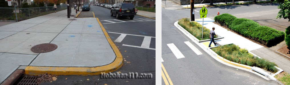
A simple curb bumpout at this corner would solve much of the problem by providing a larger, clearer pedestrian zone. Here are two existing bumpouts:
Left: a basic curb bumpout in Hoboken, New Jersey (photo from hoboken411.com). Right: a landscaped example in Seattle,
Washington (photo from myballard.com).

And here are views of 7th and Warren with and without a bumpout at the corner of the park:
From there, it is worth seeing if the rest of the park's perimeter would benefit from similar attention. The easier we can make it for people to cross the street to the park, the more users the park will have. And indeed, when deployed on both sides of an intersection, curb bumpouts can reduce pedestrian crossing distance by as much as fifty percent. They have many other advantages compared to straight-curbed intersections: they allow roadway signs to be placed closer to drivers' center of vision. When used as planting beds, they reduce surface water runoff into the roadway. And they have a generally positive effect on parking: they don't steal spaces because their locations already are no-parking zones, and they make it more difficult for scofflaws to park too close to an intersection. Perhaps most importantly, curb bumpouts alter the image of vehicle-heavy streets by advertising the right of pedestrians to inhabit intersections. Their one significant shortcoming is that they can complicate snow removal. This is less of a problem today than it was twenty years ago, however, as many municipalities now invest in smaller, more agile snow removal equipment.

As I looked into all of this, the question arose as to whether any of the streets bordering the park can be narrowed in their entirety. All the streets are now two-way; and I've never been convinced this is needed on Seventh Street and Park Place, which run along the long sides of the park. Whenever I drive on one of these streets, I find myself wondering if I should be driving on the other one.

GIF animation may not work in some mobile browsers.
The diagram at right shows a suggested pattern with one way traffic on the two long sides of the park. I don't make this suggestion lightly, as I usually am averse to converting two-way urban streets into one-way streets. Twentieth century planners frequently did this to expedite vehicle flow without regard for pedestrian experience. But on the two streets in question here, there is little chance of vehicles gaining prominence. We'd be creating narrower, one-lane, one-way streets that are quite short, and we'd grant any leftover real estate to pedestrians.

You might notice that I've continued the one-way traffic on Seventh Street into the next block heading southwest (lower left in diagram). At present, this block is ridiculously, if pleasantly, complex: the street is narrow, there's a train running down one side of it, there's pull-in parking on the other side, and there's two-way traffic. There might be a reason for this last aspect that I cannot surmise, but my working assumption is that a one-way accommodation will be adequate because Sixth Street already flows in the opposite direction. Ultimately, this is a question on which to consult the traffic engineers.

Putting all this together, I've suggested below some possible changes to the curb boundaries of the park. The sidewalks are wider and the crosswalks to the park are shorter than at present. Parking has been maintained around the entire perimeter. The biggest license I took was in showing pull-in angle parking on Park Place; I'm not sure there is enough space.

If the irregular curb geometries look odd to your eye, it likely is due to the abstract nature of the drawing. In the real world, you've almost certainly encountered similar curb shapes many times without such concerns arising.

For now, I've represented the park with an expanse of green. This does not indicate a design intent but the absence of one. I'll continue my sporadic investigations into what might happen inside the park's boundaries another time.

Thursday, September 18, 2014

A crown for Warren Street

Above: Route 9 (solid line) currently jughandles through Hudson because a narrow,
two-block section of roadway prevents a simpler, straighter route (dashed line).
Below, the existing intersection of Warren Street with Worth and Prospect.

In a recent post, I looked into rerouting U.S. Route 9 as a way of reducing truck traffic within the Hudson street grid. I raised the possibility of simplifying the route by widening a narrow, two-block stretch of Prospect and Fairview Avenues, and as an additional option, merging Prospect and Fairview into a continuous street.

In this post I'll look at the intersection where my rerouting began, the meeting of Warren Street with Prospect Avenue and Worth Avenue. Some Hudsonians complain about this intersection because of the three-way stop signs. Personally, I find communal value in the eye contact and informal coordination they call for, but at rush hour, when I almost never drive, such charms are perhaps lost.

Whether or not the intersection is a failure from a traffic standpoint, it is most definitely a failure from a civic standpoint. This is an important intersection in Hudson. It marks the head of Warren Street, the cultural and commercial spine of the city, a street celebrated for its architecture, restaurants, and galleries. But while the bottom end of Warren Street is anchored by a promontory overlooking the Hudson River, here there is no indication of the street's significance. There is no major building or space to complete the street axis and pull walkers to its top end; the strongest architectural gestures are an auto repair garage and a marginally maintained, 1870-ish flop house. Besides presenting a significant aesthetic problem, this represents an economic and cultural problem, as properties at this end of Warren Street have tended to languish.
Warren Street is the commercial and cultural spine of Hudson. It is is received by a park at the Hudson River, but it lacks a
significant marker at its upper end.

Below I offer a suggestion for anchoring the top of Warren Street. I've realigned Prospect and Worth Avenues into a continuous street, and extended Warren to meet them in a T. I also rerouted the alley behind Worth Avenue to connect with Prison Alley. These changes would result in the loss of two houses (one architecturally undistinguished) and the auto repair garage. The gain is a clear beginning/end to Hudson's main street and a large, developable parcel to the southeast.
A street realignment and new building and plaza offer a civic gesture at the head of Warren Street.


Portland, Maine
On the new site I've suggested a large building and plaza to preside over Warren Street. The location lends itself to a public building such as county offices, a police station, or a library. Unfortunately, these functions are all in the process of being relocated to other sites in Hudson. A church, grand hotel, or apartment building might work, and the proximity of the hospital suggests an administration building. However, some of these uses might not lend the right civic note. But it's fun to imagine something new and impactful at this location. A good street should have a good beginning. And a good end.

Tuesday, September 16, 2014

Developing the Hudson hinterlands
Part 1: Put your money on sprawl

Last month, the Register-Star reported that the Hudson Common Council has been asked to explore the transfer of a 33-acre parcel from the school district to the city. The city would in turn sell the unused parcel, located behind Hudson High School, for private development. This would generate revenues for the city through the sale as well as through future tax revenues.

Fiscally speaking, this seems like an excellent idea. Unfortunately, it is an inducement to create sprawl. The site is located far from existing physical and social infrastructure, most notably the Hudson grid. Presumably it would receive residential development, but anything built on the site will be automobile dependent.
A 33-acre parcel behind Hudson High School may be made available for private development.

Not far away, in Hudson's North Bay, the Columbia Land Conservancy has been pursuing a plan to create a conservation area. It would touch the Hudson street grid on the south and connect to the existing Greenport Conservation Area on the north. Question 1: Is there any land that the Conservancy has included in its plan that is a.) adjacent to the street grid, and b.) buildable?

The answer would seem to be "mostly no," as much of the land in the vicinity is swampy, steeply sloped, toxic, and unstable. But to the extent the answer is "yes," I pose Question 2: Can we rethink things a bit, such that the school district parcel becomes part of the conservation area and any buildable land near the city grid gets built on instead?

In Part 2, I'll look at an ambitious possibility for growing Hudson on an urban, rather than suburban, model.

Monday, September 15, 2014

Smiles through the trials

Columbia County Courthouse, Hudson, New York. Photo by Sorche Fairbank.

Doing tacky right

Gossips of Rivertown reported yesterday on a proposal for a cigar store to be created in an existing house at the corner of Seventh and Union Streets in Hudson. The application was approved by the Historic Preservation Commission, subject to the applicant providing some additional requested materials. The primary alteration to the building is a new canopy, which is intended to evoke a train station. The proposal looks like this:
There are more things wrong with this proposal than I can speak to; Carole Osterink already has addressed many of them. But I will attempt to make cheesecake out of cheese by addressing one big problem: The proposed roof canopy steps down awkwardly, and it has a meaningless, unused space beneath its lower portion.

Below I've suggested building a raised platform at the same height as the existing front stoop. This would allow the roof canopy to extend horizontally, more clearly evoking the desired imagery of a train platform. The raised porch would do a better job of concealing the parking behind it, and its usersI imagine the space serving as a smoking porchwould be at platform level relative to the passing trains. If only the fitness center were still across the street, we could all enjoy the theater of the smokers and the treadmillers huffing and puffing in unison.
With all that said and drawn, I don't think either proposal is legal, as the roof appears to extend over the public sidewalk. If so, surely someone will notice this before a building permit is granted... um, right? 

UPDATE, 10:50AM: I took a look at the property on Bing, and the existing house appears to sit back from the sidewalk a couple feet relative to its neighbors. So perhaps the roof does not violate the zoning setback after all.